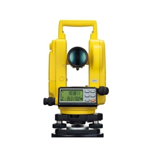
This cost-effective Electronic Digital Theodolite provides excellent performance, reliable quality and practical operation for any construction application.
The body style is similar to a Topcon Digital Theodolite and is combined with easy to use operation.
The smart appearance and reasonable structure is as attractive as its price.
• Tribrach.
• AA Rechargeable Batteries (4 each).
• Lens Cap.
• Operator's Manual.
• Hard carrying case.
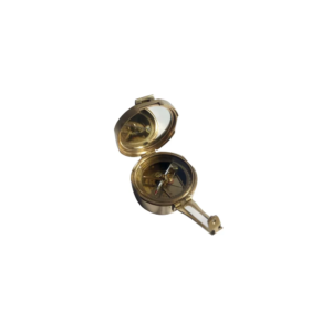
Clinometer Handle Compass is a reproduction of an antique Clinometer compass. The Handle Compass gets its name from its "handle" shaped sight, which actually serves two purposes With the compass level, an object can be viewed through the peep sights to determine its magnetic heading. The second and most interesting purpose is when tilting the compass on its side and viewing an object through the sights, its angle of elevation or declination can be found. A weighted pendulous arm beneath the compass needle can be read from one of three scales : Angle in degrees beneath the zenith (from straight up), angle in degrees of elevation or declination, and in inches per yard of slope. The compass has a needle lift mechanism to protect the compass jewel and the pendulous arm when being transported.
Vernier Transit Theodolite German Pattern 10 Sec.
Accuracy All Metal Body erect image, coated lens High Range Imported with Powder Coated Colured Deluxe Folding Telescopic Tripod in Cartying case complete with all standard accessories.
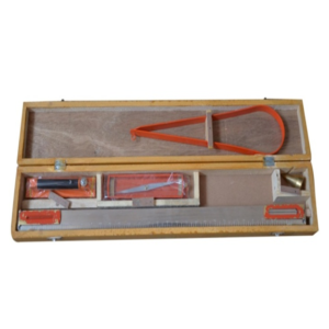
We offer a wide range of very high quality Plane Table Accessories that are suitable for maps preparation and recording topography in various engineering surveys.
This outfit consists of a plane table board with a fitted tripod.
These products undergo various quality tests at each level of its production to ensure good quality and flawless performances.
These products are basically used in the construction industry for the purpose for surveying the land for commercial use.
The Hand Level is a small, economical level for use with preliminary surveys to determine traveller way or cable way steel work elevations and other feasibility type site reconnaissance work.
The Abney Level is very similar to a clinometer in that it is used to measure the value of a slope by means of arc measure and grade percentage.
Specification of Abney Level
• Used to determine slope angle, tree heights etc
• Graduated 0-+/-90 degrees, 0-+/-100% on a stationary arc
• Vernier reads to 10
• Scale pointer incorporates friction thumb lock
• Includes carry case
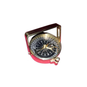
We offer Brunton Compass (Geological Compass) which is available in a leather or wooden case.
This compass differs from modern compasses, as it utilizes magnetic induction damping rather than fluid to dampen needle oscillation.
It is widely used by geologists and surveyors to make accurate degree and angle.
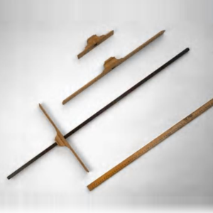
The Cross-Staff was used at sea from the beginning of the 16th century until the first half of the 18th century.
It was used to measure the sun's altitude, especially at the meridian passage. With the knowledge of the sun's declination, the mariner could then obtain his latitude.
The staff is original, with the inscription.
The cross pieces are replicas. Different cross pieces were used depending on the altitude.
A different scale is on each side of the staff.
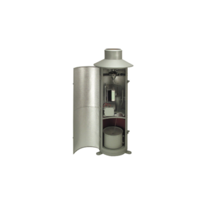
Rain gauge is designed to measure the precipitation. This small Version consisting of upper and lower housing part, measuring cylinder; Housing made of stainless steel, orifice rim made of brass.
Type 7019.0000 can be supplied with a receiving area of 100 cm2. (This type is not conforming to meteorological standards).
• Receiving area : 100 cm².
• Rain measure (graduated glass) : 250 cm³.
• Measuring range : 0 t0 25 mm precipitation (relative to a receiving area of 100 cm²).
• Graduation : 1/1 mm precipitation.
• Dimensions : dia 115 mm; height 300 mm.
• Weight : approx. 0.8 kg.


Reviews
There are no reviews yet.